
Exhibit of Historical Images Opens Nov. 11
A collection of some of the earliest maps and drawings of Western New York are being donated to the University of Rochester, which will feature the rare prints in a free exhibition in Rush Rhees Library. The exhibit opens Nov. 11 with a dedication ceremony at 4 p.m. in Rare Books and Special Collections.
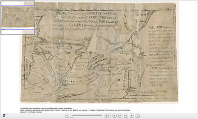
The collection includes the first map printed in the colony of New York, dated 1723, as well as the earliest known drawing of the region, a circa 1768 etching of the Upper Falls of the Genesee River.
The prints are two of more than 40 rare maps, prints, books, and copper engravings recently donated to the library's Rare Books and Special Collections Department by Dr. Seymour Schwartz. The Distinguished Alumni Professor of Surgery in the University's School of Medicine and Dentistry, Schwartz also is a renowned map historian. The collection charts the 18th- and 19th-century development of Western New York from its days as the home of Native American tribes to its division into vast land tracks in the Phelps and Gorham Purchase to its emergence as a commercial shipping artery along the newly constructed Erie Canal.
Along with Schwartz's maps, the donation includes rare drawings of the area collected by Schwartz's late wife, Dr. Ruth Schwartz. An accomplished gynecologist and clinical professor at Rochester, she was also listed among the "Best Women Doctors in America" by Harper's Bazaar magazine.
"The collection is a landmark acquisition for the library," says Nancy Martin, the John M. and Barbara Keil University Archivist. The prints will compliment other important archives at the University, including collections focused on Susan B. Anthony, Frederick Douglass, William Henry Seward, and Lewis Henry Morgan.
The oldest images in the Schwartz collection "show how people saw the country, which was a virtual wilderness at that time," says Martin. Although these maps and sketches were created for utilitarian purposes — for surveys, military operations, and engineering projects — they are "almost accidentally, beautiful," Martin says.
Schwartz concurs. "Maps are a graphic representation of history," he says. "Many of them are very elegant works of art. So the visual senses and the intellectual senses are satisfied by a single document."
Included in the exhibit is the book that launched Schwartz's interest in maps, Maps and Map-Makers by R. V. Tooley, given to him by his wife in 1963 as a present on his 35th birthday. At the time, Schwartz already was a well-established surgeon and a newly tenured member of the Rochester School of Medicine and Dentistry. He would soon go on to author the authoritative textbook, Principles of Surgery, a standard in the field. Eventually, over his more than 50-year career at Rochester, the educator and researcher would pen eight other medical texts, author some 300 scientific papers, and edit several of the most respected journals on surgery.
At this midpoint in his career, however, his wife believed Schwartz needed a "hobby" — an interest that would engage his curiosity beyond the operating room. Because of his love of history, she hit upon the idea of cartography – a word he actually encountered for the first time when he opened the pages of her gift.
What began as a hobby quickly blossomed into a scholarly passion. With an initial purchase of a 1795 map of the state of New York, Schwartz amassed over the next half century one of the most acclaimed collections of rare maps of North America. His holdings focus on maps of the 16th, 17th, and 18th centuries, documenting Europe's earliest contact with and understanding of the New World. In 2008, Schwartz bequeathed more than 200 of his rare maps to the University of Virginia, many of which can be viewed online. "The University of Rochester library is delighted to be receiving that part of his collection which relates to this region," says Martin.
More than a collector, Schwartz has authored seven books on cartography, including the definitive reference work coauthored with Ralph Ehrenberg, The Mapping of America (Abrams, 1980). He also has served on the boards of the National Museum of American History of the Smithsonian Institution and the Geography and Map Division of the Library of Congress.
The exhibit is open through April 30, 2011, and can be viewed Monday through Friday from 9 a.m. to 5 p.m. and on Saturday 11 a.m. to 3 p.m. Metered parking is available on campus weekdays, or visitors can pay at the information booth for a parking token that provides access to the library parking lot. Parking in the library lot is free on Saturday.