Features
The inauguration of Sarah Mangelsdorf as Rochester’s 11th president has the University looking not only forward, but also more than 150 years into the past to consider the institution’s roots and the paths that have led to this point in its history.
Take a Closer Look Online
To see these and additional maps in detail, visit https://rbscpexhibits.lib.rochester.edu/exhibits/show/maps-meliora.The land on which the University stands and the region it inhabits have a long history, too—and early maps and other materials are reminders of less familiar stories. They show the thirst for trade, land, and capital that European settlers and speculators brought to the home of the Haudenosaunee, the confederacy of the Mohawk, Oneida, Onondaga, Cayuga, Seneca, and, later, Tuscarora nations who lived between the Genesee and Hudson Rivers. They reveal the 19th-century boomtown years of Rochester, and they show the University stirring to life. And they offer another chapter in the origin story of the River Campus, with Oak Hill Country Club’s acquisition in 1901 of its riverside land from the estate of a woman born as Julia Lewis.
“Apart from telling us where we’ve been and where we’ve gotten to—not just literally, but figuratively—maps can be viewed as artwork,” says Melissa Mead, the John M. and Barbara Keil University Archivist and Rochester Collections Librarian. “You’re also seeing how someone explored and what they thought was important. And maps can show a legal or ethical history and help us understand what happened and where there has been an injustice.”
Longtime and avid map collector Seymour Schwartz ’57M (Res), who holds the title of Distinguished Alumni Professor of Surgery, recently gave the University a window into the past through an 18th-century manuscript map of “Genesee Country.” The map, a gift in honor of Mangelsdorf’s inauguration, is now part of the Dr. Ruth W. Schwartz and Dr. Seymour I. Schwartz Collection in the Department of Rare Books, Special Collections, and Preservation. Along with some of the other maps and papers highlighted here, it sets local landmarks within the long view of history.
Trade Mapping
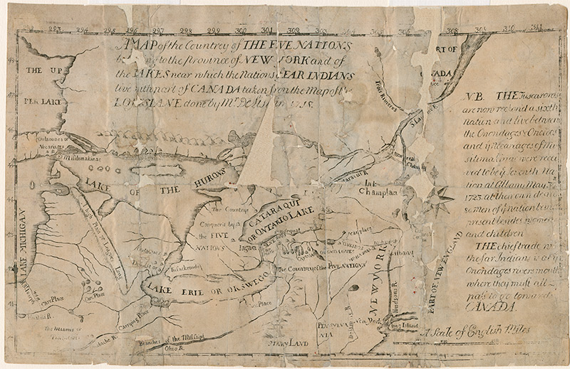
In 1724, almost a century before the City of Rochester’s founding, Surveyor General Cadwallader Colden (1688–1776) produced the first map engraved in the Province of New York. Only two maps have survived from the original production—this is one of them.
A graduate of the University of Edinburgh, Colden trained as a physician but was a bit of a Renaissance man, laboring as a businessman, botanist, farmer, and politician. For instance, his interest in plants prompted correspondence with Swedish botanist Carl Linnaeus, considered the father of modern taxonomy.
Colden was appointed as the surveyor general of New York in 1720. Several decades later, he would become New York’s lieutenant—and eventually acting—governor. But it was his early involvement in cartography that produced “A Map of the Countrey [sic] of the Five Nations.” The five nations to which the title refers are the Mohawk, Oneida, Onondaga, Cayuga, and Seneca peoples, also known as the Haudenosaunee.
Today, the map provides insight into a Eurocentric perspective on the Great Lakes region in the early 18th century. Colden, who remained loyal to the British Crown until his death, used the map to help make a case for extending British commerce in North America. He highlighted the advantages of increasing trade with Native American tribes and cited the “Mohawks River” as a source of rich soil.
Jane Colden, his fifth child, was born in the year that this map was created. An early expert in Linnaean plant classification, she’s considered the first US woman botanist. His grandson, Cadwallader David Colden, was New York City’s mayor from 1818 to 1821.
Finding Purchase
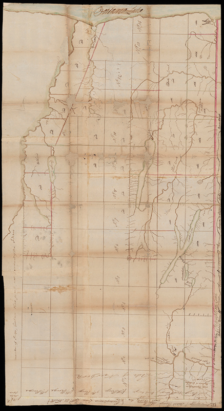
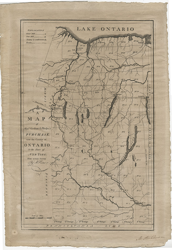
When the dust of the American Revolution settled—and perhaps sooner than that—a massive land grab took place. Oliver Phelps (1721–1821) and Nathaniel Gorham (1783–1796) were among the wealthy speculators seizing extensive tracts of central and western New York. Helped by the Treaty of Hartford, the Massachusetts businessmen took ownership of six million acres in a $1 million agreement known as the Phelps and Gorham Purchase of 1788.
With Schwartz’s recent gift, the Department of Rare Books, Special Collections, and Preservation now holds “sister” maps of the area purchased by Phelps and Gorham: the manuscript made by Samuel Preston (1756–1834) and a rare engraved map based on a survey conducted by Augustus Porter (1769–1849).
Preston’s manuscript shows the eastern portion of “Genesee Country,” a small piece of a much larger tract of land in western New York, which was bitterly fought over by several interested parties, including Native Americans, colonists, and land companies. Here, it extends from Lake Ontario in the north down to the border with Pennsylvania, and from Seneca Lake to the Genesee River. The north-south lines delineate ranges; the east-west lines mark out townships.
“[Mapmakers] used this system to impose structure on the land,” Mead says. “The system they used to recognize and sell land was established in 1785, based on an idea of Thomas Jefferson’s.”
Mapping by Ear
Thomas Davies first surveyed the area in 1766. Porter followed in 1788 for the Phelps and Gorham Purchase and assessed it again in 1791 and 1792. Porter’s map was engraved by the prolific Amos Doolittle (1754–1832) and published in 1794.
Porter, a Connecticut native, was also the surveyor in the Holland Purchase of the 1790s, when the Holland Land Company bought the western two-thirds of the Phelps and Gorham Purchase. In 1808, Porter moved to the Niagara Falls region, where he settled and became the first judge of the newly formed Niagara County. The manuscript’s lack of detail may be evidence that Preston based his drawing on Porter’s initial survey.
“Most maps of discovery were drawn by people who had never been to the place,” says Schwartz. “These drawings are expressions of what the mapmaker heard from travelers and local tribes.”
In addition to being a surveyor, Preston was a prominent Quaker and conveyancer. He undertook many expeditions throughout Delaware, Maryland, and Pennsylvania as a business agent for several Philadelphia merchants, including Henry Drinker. As a land agent, Preston arrived in Stockport, New York, in 1787 to survey the lands, and he eventually settled there. Drinker and his associates likely pushed Preston to draw the map for a speculative purchase.
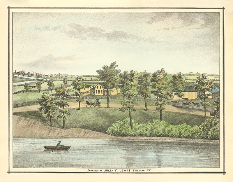
Land of Julia Lewis
Rush Rhees, George W. Todd, and George Eastman are among those who are most responsible for the University’s expansion outside the Prince Street Campus. Julia Lewis Cochrane Adlington played an indirect role in the effort that resulted in the River Campus.
Lewis was born June 1, 1848, to Simeon and Sophia Lewis. She studied at the Buffalo Female Academy—now the Buffalo Seminary, one of New York’s oldest preparatory schools for girls—graduating in June 1866.
On July 19, 1877, Lewis married James Cochrane. Sadly, Cochrane died just four years later. Lewis married again in 1895, taking Joseph Adlington as her husband. Lewis and Adlington remained together until Lewis’s death in 1899.
Sometime after the death of her parents, Lewis inherited her family’s farm, land she retained ownership of throughout her life. Two years after her death, Oak Hill Country Club leased (and eventually purchased) the property from the Lewis-Adlington estate and converted the Lewis family’s farmhouse into its first clubhouse.
Lewis’s retention of the land throughout her two marriages was made possible by the Married Women’s Property Act, enacted in New York state less than two months before her birth. The law gave women the legal right to own and control property. Previously, marriage effectively ended a woman’s legal existence wherever the English legal tradition reigned, requiring her to forfeit any property she had to her husband. Thanks to the new legislation—which became a model for other states seeking reform—Lewis never lost control of her family’s land.
Boomtown University
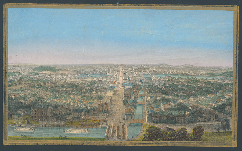
While Prince Street was the site of Rochester’s first campus, the University’s first home was on Buffalo Street (now West Main Street), in the United States Hotel.
The three-story hotel (the reddish-brown building facing Buffalo Street in the left foreground) was built to attract weary travelers on the Erie Canal. When the business failed to find financial success, the building went on to house other ventures, including a training school, a seminary, a railroad station, and a church. The University moved in when it was founded in 1850 and stayed until 1861.
Artist John William Hill, through his depiction of life on and around the canal, shows how vibrant Rochester was, says Mead.
“We were a boomtown in the 1850s,” she says. “The canal made us. So, putting it front and center shows how wonderful it was. And we’re also able to see how the canal was used and what the ships that traveled it looked like.”
The print, which the University holds in multiple sizes, is extremely popular and has been widely reproduced.
Scholar and historian of urban planning John Reps describes the perspective of the map as “simple but dramatic.” He notes that, like other bird’s-eye urban images, it “invites the observer to enter the picture and roam around in search of details of city life in a busy and prospering community on the Erie Canal.”
Rochester Premiere
Rochester was still finding its legs as a men’s college when railroad investor Azariah Boody and pioneering anthropologist Lewis Henry Morgan began working on a college for women. In 1852, Barleywood Female University began accepting students.
Boody helped immediately legitimize the venture by giving the school six acres of his own land on which to build. But in its nascent stage, the school needed money more than acreage. Its financial woes continued, and after only a year in session, Barleywood closed its doors.
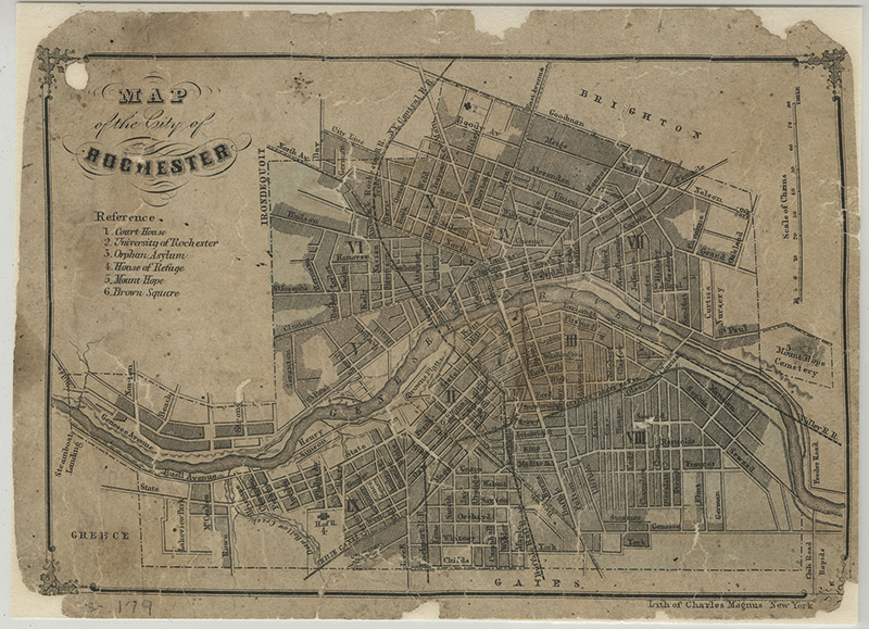
At the same time, a few blocks away, Rochester was actively seeking to move out of the United States Hotel. Boody offered the University the Barleywood land, plus an extra two acres. On July 14, 1853, the University accepted his proposal for the land that would later become the Prince Street Campus.
This lithograph map of the City of Rochester in 1855 was, like the Hill lithograph, published by Charles Magnus of New York. Born Julian Carl Magnus in 1826 in Elbereld, Germany, he immigrated with his family to New York in the mid-19th century. Wintherthur Library, home to the Charles Magnus Collection, notes that Magnus began printing maps in the 1850s and printed hundreds of patriotic song sheets and illustrated envelopes during the Civil War.
The University of Rochester is called out (as “2”) in Magnus’s lithograph, the first time the University was represented on a map.
Rochester Review
Fall 2019
Vol. 82, No. 1
Get the PDF